


La Garde

pierre.chau
User
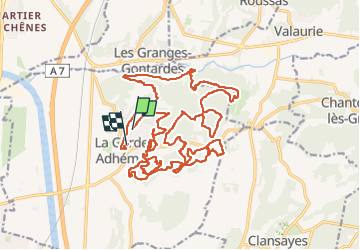

Length
30 km

Max alt
233 m

Uphill gradient
536 m
Km-Effort
37 km

Min alt
77 m

Downhill gradient
561 m
Boucle
No
Creation date :
2024-04-21 07:46:23.0
Updated on :
2024-04-21 11:59:02.49

FREE GPS app for hiking
 SityTrail
IGN / Geographical institutes
SityTrail Plus
The world is yours!
About
Trail of 30 km to be discovered at Auvergne-Rhône-Alpes, Drôme, La Garde-Adhémar. This trail is proposed by pierre.chau.
Description
VTT
Positioning
Country:
France
Region :
Auvergne-Rhône-Alpes
Department/Province :
Drôme
Municipality :
La Garde-Adhémar
Location:
Unknown
Start:(Dec)
Start:(UTM)
639898 ; 4917608 (31T) N.
Comments